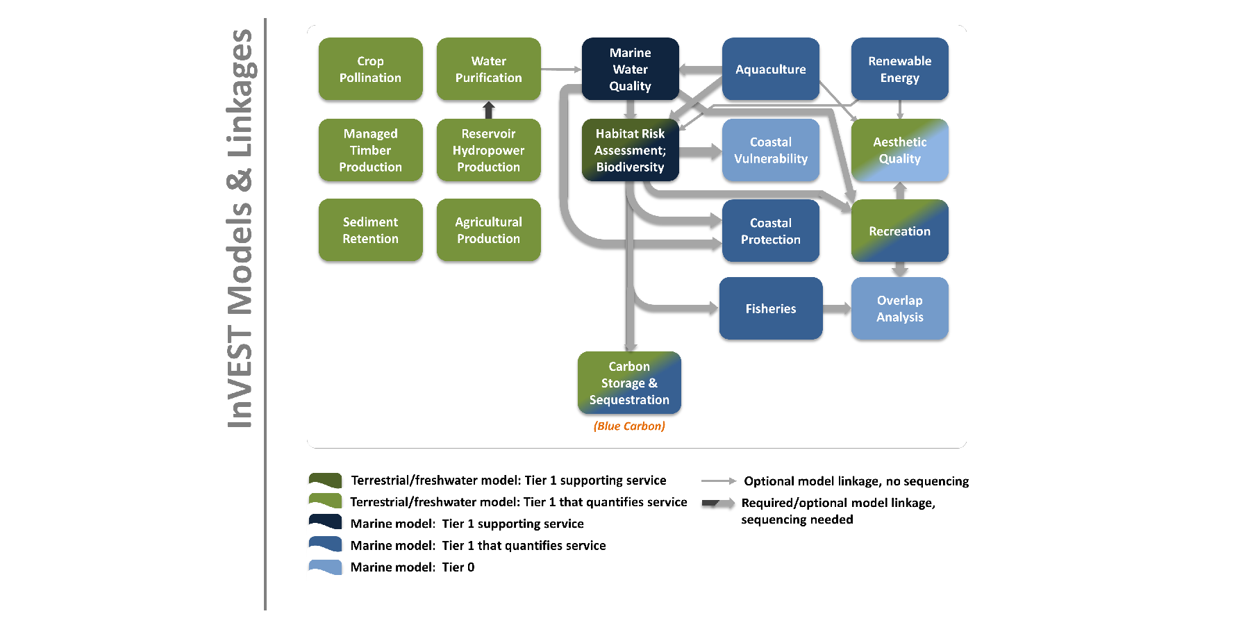
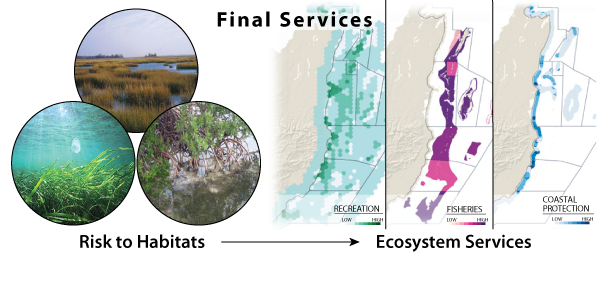
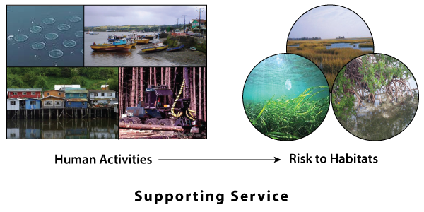


| Purpose | Evaluates risks posed to multiple habitats in terms of exposure to human activities and the habitat-specific consequence of that exposure for delivery of environmental services |
| Links | Video | Summary | Documentation |
| Use-Cases | Barbados | Belize | Mozambique | Vancouver Island |
| Publications | Arkema, Katie K., et al. "Embedding ecosystem services in coastal planning leads to better outcomes for people and nature." Proceedings of the National Academy of Sciences 112.24 (2015): 7390-7395. doi:10.1073/pnas.1406483112 Arkema, Katie K., et al. "Assessing habitat risk from human activities to inform coastal and marine spatial planning: a demonstration in Belize." Environmental Research Letters 9.11 (2014): 114016. doi:10.1088/1748-9326/9/11/114016 Guerry, Anne D., et al. "Modeling benefits from nature: using ecosystem services to inform coastal and marine spatial planning." International Journal of Biodiversity Science, Ecosystem Services & Management 8.1-2 (2012): 107-121. doi:10.1080/21513732.2011.647835 |
| Purpose | Assesses how management and human activities influence the water quality and structure of coastal and estuarine ecosystems |
| Links | Summary | Documentation |
| Use-Cases | Vancouver Island |
| Publications | Guerry, Anne D., et al. "Modeling benefits from nature: using ecosystem services to inform coastal and marine spatial planning." International Journal of Biodiversity Science, Ecosystem Services & Management 8.1-2 (2012): 107-121. doi:10.1080/21513732.2011.647835 |
| Purpose | Uses geophysical and natural habitat characteristics of coastal landscapes to compare their exposure to erosion and flooding in severe weather |
| Links | Summary | Documentation |
| Use-Cases | Barbados | Belize | California | Mozambique | New England | Vancouver Island |
| Publications | Arkema, Katie K., et al. "Coastal habitats shield people and property from sea-level rise and storms." Nature Climate Change (2013). doi:10.1038/nclimate1944 Langridge, Suzanne M., et al. "Key lessons for incorporating natural infrastructure into regional climate adaptation planning." Ocean & Coastal Management 95 (2014): 189-197. doi:10.1016/j.ocecoaman.2014.03.019 |
| Purpose | Estimates the relative importance of regions for human use; outputs can help decision-makers weigh potential conflicts among spatially-explicit management options that involve new activities or new infrastructure |
| Links | Summary | Documentation |
| Use-Cases | Belize | New England | Vancouver Island |
| Publications | Kim, Choong-Ki, et al. "Catching the Right Wave: Evaluating Wave Energy Resources and Potential Compatibility with Existing Marine and Coastal Uses." PloS one 7.11 (2012): e47598. doi:10.1371/journal.pone.0047598 Griffin, R., et al. "Incorporating the visibility of coastal energy infrastructure into multi-criteria siting decisions." Marine Policy, 62, 218-223. doi:10.1016/j.marpol.2015.09.024 |
| Purpose | Estimates the current amount of carbon stored in coastal-marine ecosystems and values the amount of sequestered carbon over time |
| Links | Summary | Documentation |
| Use-Cases | Belize |
| Publications | None |
| Purpose | Quantifies the protective services provided by nearshore habitats in terms of avoided erosion and flood mitigation |
| Links | Video | Summary | Documentation |
| Use-Cases | Barbados | Belize | California | Vancouver Island |
| Publications | Arkema, Katie K., et al. "Embedding ecosystem services in coastal planning leads to better outcomes for people and nature." Proceedings of the National Academy of Sciences 112.24 (2015): 7390-7395. doi:10.1073/pnas.1406483112 Guannel, Greg, et al. "Integrated modeling framework to quantify the coastal protection services supplied by vegetation." Journal of Geophysical Research: Oceans (2014). doi: 10.1002/2014JC009821 |
| Purpose | Estimates the weight and economic value of Atlantic salmon grown in netpen aquaculture facilities |
| Links | Summary | Documentation |
| Use-Cases | Vancouver Island |
| Publications | None |
| Purpose | Measures the electricity generation potential of wind over ocean and large lake surfaces |
| Links | Summary | Documentation |
| Use-Cases | New England |
| Publications | Griffin, R., et al. "Incorporating the visibility of coastal energy infrastructure into multi-criteria siting decisions." Marine Policy, 62, 218-223. doi:10.1016/j.marpol.2015.09.024 |
| Purpose | Predicts the spread of person-days of recreation, based on the locations of natural habitats and other features that factor into people’s decisions about where to recreate |
| Links | Video | Summary | Documentation |
| Use-Cases | Barbados | Belize | California | Mozambique | New England | Vancouver Island |
| Publications | Arkema, Katie K., et al. "Embedding ecosystem services in coastal planning leads to better outcomes for people and nature." Proceedings of the National Academy of Sciences 112.24 (2015): 7390-7395. doi:10.1073/pnas.1406483112 Wood, Spencer A., et al. "Using social media to quantify nature-based tourism and recreation." Scientific reports 3 (2013). doi:10.1038/srep02976 |
| Purpose | Employs viewshed analysis to estimate the visibility of features or objects such as coastal development, clear-cuts or aquaculture facilities |
| Links | Summary | Documentation |
| Use-Cases | Barbados | California | New England | Vancouver Island |
| Publications | Griffin, R., et al. "Incorporating the visibility of coastal energy infrastructure into multi-criteria siting decisions." Marine Policy, 62, 218-223. doi:10.1016/j.marpol.2015.09.024 Verutes, Gregory M., et al. "Exploring scenarios of light pollution from coastal development reaching sea turtle nesting beaches near Cabo Pulmo, Mexico." Global Ecology and Conservation (2014): 170-180. doi:10.1016/j.gecco.2014.09.001 |
| Purpose | Measures and values the electricity generation potential of ocean waves |
| Links | Summary | Documentation |
| Use-Cases | California | Vancouver Island |
| Publications | Kim, Choong-Ki, et al. "Catching the Right Wave: Evaluating Wave Energy Resources and Potential Compatibility with Existing Marine and Coastal Uses." PloS one 7.11 (2012): e47598. doi:10.1371/journal.pone.0047598 |