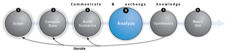
Step 4: Analyze (Assess Outcomes)

Overview
The Analyze step uses Data to assess whether outcomes of environmental changes or management actions proposed during the Scenarios step meet planning goals outlined during the Scope step. Analyses quantify how changes in ecosystems and socio-economic conditions under alternative future scenarios lead to spatially explicit changes in environmental condition, ecological function, and benefits to people. Analyses should create outputs such as maps or summary tables of metrics that allow you to adequately explore the benefits of management options, consequences of climate and other global change, and to identify synergies and tradeoffs between them (Cowling et al. 2008).
A variety of "Decision Support Tools" (DSTs) exist to facilitate analyses for marine planning (Coleman et al. 2011, Stelzenmüller et al. 2013). This does not mean that you have to choose a DST. In reality, many tools serve different purposes and can be used to meet specific planning goals. As such, DSTs have unique data requirements and create different types of results. For example, the InVEST overlap analysis tool enables users to visualize the number of human activities in a space (see examples in our Gallery). Marxan with Zones uses a quasi-optimization approach to highlight areas of greatest value for achieving multiple biodiversity and other objectives in a spatial zoning context (Makino et al. 2013, Agostini et al. 2010). Regardless of whether a DST is used, analyses should produce results that are meaningful to stakeholders participating in the marine planning process and the local beneficiaries who will be affected negatively or positively by policy decisions (Honey-Rosés and Pendleton 2013, Ruckelshaus et al. 2014).

Marine Planning Decision-Support Tools
Below we list some freely-available marine planning analysis tools. Click on the tool's name to visit its website or click on the sub-bullet links to learn how the tool was applied as part of an marine planning use-case.
- Marine InVEST - A modular toolset that enables users to quantify, visualize and compare the delivery of key ecosystem services under different scenarios of land, water, and marine uses. Outputs describe natural resources in terms of their biophysical supply, the service they provide humans, or their projected socioeconomic value. These outputs provide a framework for governments, corporations, development banks, conservation organizations and other decision makers to evaluate the impacts of their decisions on the environment and on human well-being. (Guerry et al. 2012, Kim et al. 2012, Arkema et al. 2013, Arkema et al. 2014, Arkema et al. 2015)
• Two InVEST marine planning use-cases are described at the bottom of this page.
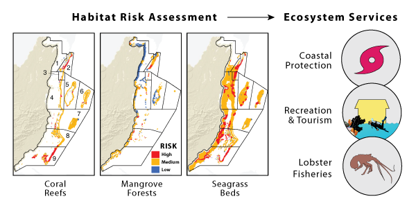
• Click the following links or image below to watch 3-min intro videos of the InVEST Habitat Risk Assesment, Coastal Protection and Tourism & Recreation model.
- ARIES is a flexible, spatially explicit ecosystem service modeling framework that uses machine learning and reasoning to allow assembly of customized models, specialized for each application context (Villa et al. 2014).
• Madagascar - ARIES marine ecosystem services models were developed for Madagascar to study coastal storm regulation and subsistence fisheries. Both of these services are critical in Madagascar due to its reliance on fisheries for protein and its susceptibility to tropical storms forming in the southwest Indian Ocean.
- Atlantis is an ecosystem model that can accommodate complex coupled human-natural systems, including food web and fleet dynamics (Link et al. 2010).
• Northern Gulf of California (Mexico) - Atlantis was used to estimate the benefits of compliance with existing fisheries regulations in the Northern Gulf of California, including spatial management, seasonal closures, gear restrictions, removal of illegal fishing, buyouts and programs to encourage gear switching, and the combination of these regulations into ‘full enforcement’.
- Coastal Resilience is a global network of practitioners who are applying an approach and web-based mapping tool designed to help communities understand their vulnerability from coastal hazards, reduce their risk and determine the value of nature-based solutions.
• Gulf of Mexico - With its high incidence of storms and hurricanes and valuable ecological and economic resources, the Gulf region is a high-risk area with great potential to demonstrate natural risk reduction solutions. The Coastal Resilience approach and tools have been applied Gulf-wide and at specific sites, including those that help identify where to implement oyster reef restoration to meet social and ecological goals.
- Human Impacts to Marine Ecosystems - Estimates and visualizes, for the first time, the global impact humans are having on the ocean's ecosystems (Halpern et al. 2008).
• California Current - Researchers applied methods developed to map cumulative impacts globally to the California Current using more comprehensive and higher-quality data for 25 human activities and 19 marine ecosystems.
- Ocean Health Index (OHI) - The OHI is a framework to comprehensively assess the benefits the ocean delivers to people using existing information and can be used to prioritize policy action (Halpern et al. 2012, Halpern et al. 2015). Assessments can be conducted at different spatial scales, with methods tailored to the specific context.
- Mapping Ocean Wealth - Informed by science, communications and policy work, Mapping Ocean Wealth visualizes in quantitative terms all that the ocean does for us today, so that we make smarter investments and decisions for the ocean of tomorrow.
- Marxan with Zones - See Scenario Development Tools
- MIMES is a suite of models that quantify the effects of land and sea use change on ecosystem services and at global, regional, and local levels using input data from GIS sources, time series, etc. to simulate ecosystem components at under different scenarios (Boumans and Costanza 2007).
• Mississippi Delta - Wetlands, Hurricanes and the Economy: The Value of Restoring the Mississippi River Delta
- SeaSketch - See Scenario Development Tools
- WRI’s Valuation Methods and Tools is an approach to conducting ecosystem valuation to inform decision making that involves three phases of a valuation effort (scoping, analysis and outreach), with an emphasis on stakeholder engagement in all phases (Waite et al. 2014).
• Caribbean - WRI’s valuation methods and tools help policymakers, civil society or other interested parties to assess the value to their economies of goods and services provided by coral reefs and to aid in setting coastal management policies. WRI offers tools for tourism/recreation, fisheries, and MPAs.

Tips
Before applying a tool:
- Make sure that the tool's outputs and purpose meet your goals (DSTs are not required for marine planning)
- Assess whether you can collect the necessary data and information to use the tool; and whether you have the expertise to parameterize and run the models
- Understand underlying assumptions and limitations of the tool
- Examine existing examples of how the tool was used
Do you know of other analysis tools that can help inform marine planning? E-mail us the details!

Frequently Asked Questions (FAQ)
Q: What guidance is available to help me choose from all the different decision-support tools for marine planning?
A: In 2011 the Center for Ocean Solutions and PacMARA released a Decision Guide: Selecting decision support tools for marine spatial planning. Decision-support tools are not needed for all stages or types of marine planning. Depending on the level of quantitative, spatial information desired to support a marine planning process, early iterations or phases of planning can often get underway with open discussions in which scientific information is included, without requiring DST application.
Q: Which metrics are most effective for highlighting future change in the distribution and delivery of ecosystem services to people?
A: It depends largely on what ecosystem service and function are under consideration. During the scoping step stakeholders should elucidate the dependencies on ecosystems, potential sources of environmental change, how these changes affect ecosystem function, and thus how ecosystem services might change. Once these connections have been hypothesized, it can be useful to measure ecosystems and their services in biophysical and economic terms. This process of working from change, through function, and then to ecological outcomes for people is important.
Q: How exactly can InVEST models be used to facilitate the marine planning process?
A: Visit our Marine InVEST page to learn about the models -or- read through the NatCap use-case summaries at the bottom of this and subsequent pages to learn how different models in the InVEST toolkit were applied for marine planning.
Q: To show the value of marine planning...has anyone modeled what an ocean region would look like with and without marine planning?
A: A recent article (Arkema et al. 2015) compared the current distribution of ecosystem services (without integrated marine planning) to three alternative futures of human use/management in the Belize coastal zone (Fig 2). It also estimated ecosystem service returns for three key services (tourism, lobster and coastal protection) based on multiple rounds of stakeholder consultations (Fig 4). In the United States, White et al. (2012) conducted a wind energy study in Massachusetts.
Q: If I have questions about using InVEST models or run into problems, where can I get help?
A: First, check the InVEST User's Guide chapter that describes your particular model of interest. Each chapter covers the theory behind the model as well as detailed information about data formatting requirements and how to interpret the results (model outputs). Within InVEST, each model includes sample input data that offers a template for how input data should be formatted. NCP-101, our online course (MOOC), includes brief videos introducing InVEST models along with natural capital fundamentals and hands-on exercises to help you learn more about our approach and tools. Also, the NatCap User Help Forum allows users to converse with other InVEST users and NatCap staff.

Links
- Arkema, Katie K., et al. "Embedding ecosystem services in coastal planning leads to better outcomes for people and nature." Proceedings of the National Academy of Sciences 112.24 (2015): 7390-7395. doi:10.1073/pnas.1406483112
- Coleman, H., et al. "Decision guide: selecting decision support tools for marine spatial planning." Center for Ocean Solutions, Stanford University, Palo Alto, CA. (2011). Available from: http://pacmara.org/tikiwiki/tiki-download_file.php?fileId=233
- Cowling, Richard M., et al. "An operational model for mainstreaming ecosystem services for implementation." Proceedings of the National Academy of Sciences 105.28 (2008): 9483-9488. doi: 10.1073/pnas.0706559105
- Guerry, Anne D., et al. "Modeling benefits from nature: using ecosystem services to inform coastal and marine spatial planning." International Journal of Biodiversity Science, Ecosystem Services & Management 8.1-2 (2012): 107-121. doi:10.1080/21513732.2011.647835
- Halpern, Benjamin S., et al. "A global map of human impact on marine ecosystems." Science 319.5865 (2008): 948-952. doi:10.1126/science.1149345
- Honey-Rosés, Jordi, and Linwood H. Pendleton. "A demand driven research agenda for ecosystem services." Ecosystem Service (2013): 160-162. doi:10.1016/j.ecoser.2013.04.007
- Kim, Choong-Ki, et al. "Catching the Right Wave: Evaluating Wave Energy Resources and Potential Compatibility with Existing Marine and Coastal Uses." PloS one 7.11 (2012): e47598. doi:10.1371/journal.pone.0047598
- Link, Jason S., Elizabeth A. Fulton, and Robert J. Gamble. "The northeast US application of ATLANTIS: a full system model exploring marine ecosystem dynamics in a living marine resource management context." Progress in Oceanography 87.1 (2010): 214-234. doi:10.1016/j.pocean.2010.09.020
- Makino, Azusa, et al. "Incorporating conservation zone effectiveness for protecting biodiversity in marine planning." PloS one 8.11 (2013): e78986. doi:10.1371/journal.pone.0078986
- Stelzenmüller, Vanessa, et al. "Practical tools to support marine spatial planning: a review and some prototype tools." Marine Policy 38 (2013): 214-227. doi:10.1016/j.marpol.2012.05.038
- Villa, Ferdinando, et al. "A methodology for adaptable and robust ecosystem services assessment." PloS one 9.3 (2014): e91001. doi:10.1371/journal.pone.0091001
- White, Crow, Benjamin S. Halpern, and Carrie V. Kappel. "Ecosystem service tradeoff analysis reveals the value of marine spatial planning for multiple ocean uses." Proceedings of the National Academy of Sciences 109.12 (2012): 4696-4701. doi: 10.1073/pnas.1114215109
- NCP-101 - A free online course developed by NatCap; modules 2-4 enable learners to apply select marine InVEST models using real data from Belize
- Marine Planning.org - Case studies illustrating the use of marine planning and ecosystem-based management (EBM) to address multiple objectives
- EBM Tools Network - Offers tools, training and webinars on coastal and marine planning and management

Use-Cases
Use the expand [+] button to learn more about this analyze step in the context of select NatCap use-cases.top
Vancouver Island
California
The InVEST coastal vulnerability model was used to identify where coastal ecosystems reduce the number of people exposed to storms and future sea level rise along the California coast. These areas were further analyzed at the county level to highlight which habitats play the biggest role in reducing numbers of people at risk and thus where to prioritize conservation of these ecosystems. This early information provided local agencies with a process to better determine how their coasts and oceans can be managed more sustainably (Langridge et al. 2014). Additional InVEST models are now being applied to map the full suite of benefits provided by coastal-marine ecosystems, including recreation opportunities, scenic quality and watershed services.
Belize
In coastal Belize, the question we were addressing in the Analyze step was "where should we site human activities to enhance ecosystem services and reduce the risk to habitats that provide these services?" We used a classic risk assessment approach (see Arkema et al. 2014 for more details about the InVEST habitat risk assessment model) to map cumulative risk to habitats from eight coastal-marine human uses. To assess delivery of services in the current and several future management scenarios, we assumed a relationship between levels of risk to habitats and the amount of "functional" habitat (healthy ecosystems that are capable of providing benefits to people, Arkema et al. in review). We used estimates of the area of functional habitat in each analysis unit and planning region as inputs into three InVEST models coastal protection, fisheries, and tourism services. Model results were used to illustrate where human activities pose the greatest risk to ecosystems and the resulting changes in ecosystem service values (both biophysical and economic).