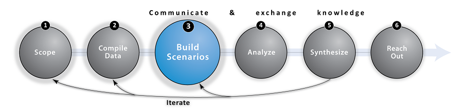
Step 3: Build Scenarios

Overview and Goals
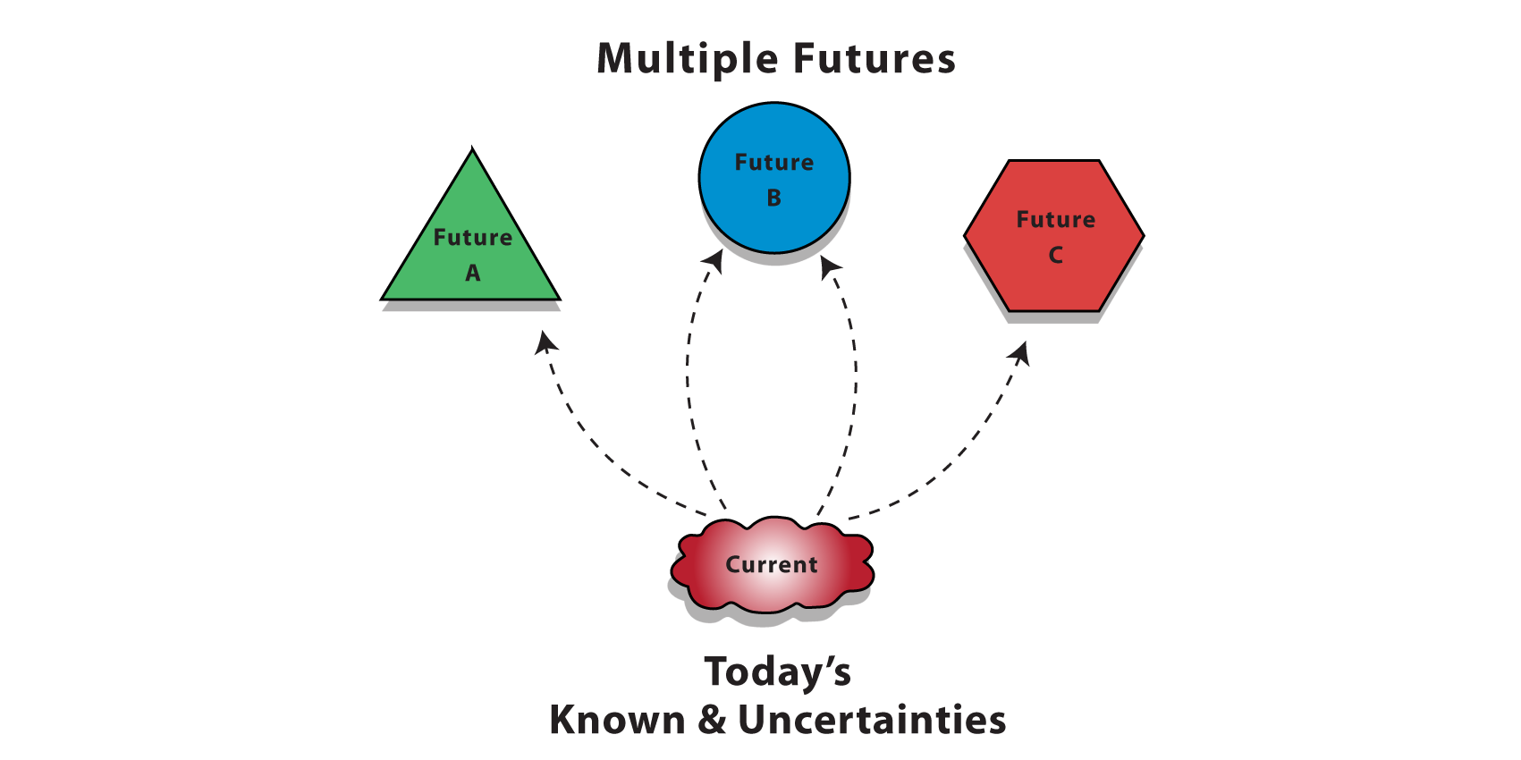
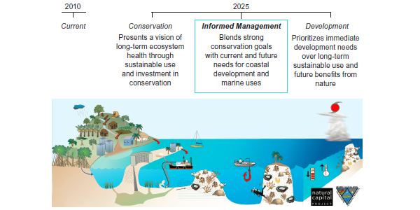
Scenarios are simplified descriptions of possible futures, used to illuminate choices and consequences. They are not predictions, but instead plausible storylines of what the future could look like. Developing a set of alternative scenarios can be useful for examining how actions taken today may play out in the future. In the context of marine planning, scenarios can be used to demonstrate how ecosystem service benefits will change under different management, development, restoration, or climate change alternatives and indicate the synergies and trade-offs in objectives among options. Scenarios provide an important tool for planning and designing interventions to optimize the multiple objectives identified during the Scope step.
Scenario analysis can help uncover unintended tradeoffs or surprising win-wins that are otherwise difficult to imagine when many human activities and social, economic, and ecological objectives interact in marine systems. Scenarios are most usefully developed as part of a stakeholder-driven process that elicits storylines with key drivers affecting alternative pathways to the future (Henrichs et al. 2010). Differences among stakeholders in their preferences for human use patterns and options for management or future climate conditions can be reflected in alternatives and then consequences for shared objectives are visualized as model outputs (Analyze & Synthesize steps). Scenario development can be an effective learning process for stakeholders, who can use results to evaluate whether policies secure ecosystem services under uncertain futures, or to consider new policies or management strategies. Spatially explicit scenarios can be generated from models (e.g., Henrichs et al. 2010), scenario tools (see tool links below), or expert elicitation.

Tips
- Alternative, spatially explicit scenarios should be distinct (see page 5 of our Scenarios Primer for a complete list of effective scenario characteristics), and at least 2 should be analyzed to understand potential effects of management, climate, or other global change drivers on objectives relative to baseline conditions
- Explore our compilation of use-cases (below) to help find a scenario development tool that matches your project needs
- Recognize that although it is a time consuming process to adequately incorporate a diverse range of stakeholder visions and values; the potential for building consensus around the ultimate plan is more likely with early participation from those who will be affected (stakeholders)
- Read the excellent summary from the VALMER project documenting lessons learnt during their scenario development process

Scenario Development Tools and Use-Cases
Below we list some popular scenario development tools. Click on the sub-bullets to learn more about how they were applied in marine planning use-cases.
- InSEAM is a free online map annotation tool enabling multiple users to draw features on a base map. These drawings and annotations can be organized and downloaded as digital layers to facilitate the scenario development process. We have found that people tend to trust data more when they participate in its compilation or collection where possible.
• Belize - NatCap used InSEAM to help stakeholders map and discuss possible future changes to the coast of Belize. (see Rosenthal et al. 2013, pages 5-7 "Stakeholder Engagement and Review").
- InVEST Scenario Generator provides a relatively simple method for generating future scenarios based on land use change suitability.
• ScenarioHub.net - A resource center developed by World Wildlife Fund and the Natural Capital Project, where you can learn about scenarios and scenario mapping, find appropriate scenario tools, and use the InVEST Scenario Generator workspace.
• Vietnam - InVEST Scenario Generator was used to map changes in mangrove ecosystems for two future land use scenarios in the Ca Mau province of Vietnam.
- InVEST Habitat Risk Assessment (HRA) model captures explicitly how and where human activities affect habitat structure and function. The HRA model can be used to translate scenarios of human uses, activities, and future climate into spatially explicit consequences for habitat distribution and condition.
• Belize - InVEST HRA was used to assess the combined risk to habitats (coral reefs, mangrove forests and seagrass beds) from multiple ocean uses. These results were used to inform the design of the country's first Integrated Coastal Zone Management (ICZM) Plan (Arkema et al. 2014).
- Coastal RIOS optimally sites habitat protection and restoration activities based on multiple planning objectives.
• West Florida - Coastal RIOS is helping assess proposed actions following the Deepwater Horizon oil spill in the Gulf of Mexico, including the identification of best places to protect or restore seagrass, oyster, marsh, and dune habitats while balancing coastal protection, tourism and recreation, and fisheries objectives.
- SeaSketch is a pay-for-service tool for ocean planners, stakeholders and the public that enables participatory marine spatial planning processes.
• North Pacific Coast - the Marine Planning Partnership (MaPP) is integrating Marxan outputs in their SeaSketch project. MaPP is using SeaSketch to draft protection management zones in four sub-regions, and discuss the implications of these with marine stakeholders.
• Hauraki Gulf (New Zealand) - SeaSketch is being used by a Stakeholder Working Group to create a marine spatial plan for the Hauraki Gulf Marine Park. This plan is being developed to ensure the long-term maintenance and enhancement of the Gulf's cultural, environmental, economic, and social values.
- Habitat Priority Planner is part of NOAA's Digital Coast Partnership, and aids in making decisions about conservation, restoration, and planning by providing a means for obtaining critical habitat analyses that are consistent, repeatable, and transparent.
- Marxan with Zones facilitates design and configuration of protected area networks, to meet ecological, social, and economic objectives
•
St. Kitts and Nevis - Marxan with Zones generated a series of scenario-analysis maps and helped organize a wide range of information and assign actions to specific locations across the seascape. This tool was used to support the zoning decision-making process in St. Kitts and Nevis by The Nature Conservancy (Agostini et al. 2010).
- TerrSet (formerly IDRISI) is a proprietary tool that allows users to rapidly analyze land cover change and simulate future land change scenarios.
- SLAMM simulates the dominant processes involved in wetland conversions and shoreline modifications during long-term sea level rise. The model produces maps of the distributions of wetlands under conditions of accelerated sea level rise and summarizes results in tabular and graphical form.

Frequently Asked Questions (FAQ)
Q: How do I get started developing scenarios for marine planning?
A: Scenario development is dependent on location, partners, and objectives. Identification of goals, ecosystem-service objectives, and key human and global change drivers can occur through a stakeholder engagement process, using guidance from existing plans and reports, or a combination of approaches (McKenzie et al. 2014). Refer to our list of scenarios development tools for ways to get started on the technical work involved in translating scenarios into inputs for models in the next step (Analyze). For example, our Belize use-case (described below) used stakeholder engagement and a habitat risk assessment tool to draft and refine three alternative future scenarios.
Q: Can Marxan, SeaSketch or other tools be used in conjunction with InVEST models?
A: Certainly! Multiple decision-support tools were used by the Marine Planning Partnership to bring ecosystem services information into the planning process. See the British Columbia use-case example at the bottom of this page. Marxan produces zoning configurations that achieve multiple planning objectives. InVEST can use zoning maps produced by Marxan (e.g., optimal locations for different sectoral uses) to assess outcomes for people based on the future changes to ecosystem structure and function resulting from activities allowed in the zones. NatCap has also used other scenario tools as a means to create inputs for InVEST models. For example, NatCap and TNC used outputs from the SLAMM (Sea Level Affecting Marshes Model) in the Galveston Bay to predict where salt marshes migrate under different sea level rise scenarios through the year 2100. These scenario maps were in turn used as inputs to the InVEST coastal protection and coastal blue carbon models (Guannel et al. 2014).
Q: Do you have any recommendations for participatory mapping (PGIS) resources that can be used by marine spatial planners?
A: There are many PGIS tools out there, some are free and others are "pay to play". A few are listed in our scenario development tools section. NatCap developed InSEAM to enable planners to quickly store and share digital drawings and annotations. SeaSketch is more advanced with custom analytics but requires an experienced programmer and paid subscription.
Q: When are my scenarios final?
A: After preliminary analyses and visualization of the consequences of scenarios for objectives, scenarios can be iteratively refined to better reflect plausible or desired alternative futures. Throughout the scenario development process, continue consulting stakeholders and local experts to ensure that your scenarios are plausible, desirable, and will help your team produce information that can answer your specific research questions (e.g., Arkema et al. 2014).

Links
- Arkema, Katie K., et al. "Assessing habitat risk from human activities to inform coastal and marine spatial planning: a demonstration in Belize." Environmental Research Letters 9.11 (2014): 114016. doi:10.1088/1748-9326/9/11/114016
- Arkema, Katie K., et al. "Embedding ecosystem services in coastal planning leads to better outcomes for people and nature." Proceedings of the National Academy of Sciences 112.24 (2015): 7390-7395. doi:10.1073/pnas.1406483112
- Henrichs, Thomas, et al. "Scenario development and analysis for forward-looking ecosystem assessments." Human Well-Being (2010): 151. ISBN:978-1-59726-711-3
- Tradeoff! - A series of simple stakeholder exercises created by the Natural Capital Project that challenge participants to consider the consequences of development on environment and how these actions will impact the benefits ecosystems provide to people
- Scenario Primer - A quick guide that introduces scenarios and how they can be used with InVEST. It also provides guidance on what makes an effective scenario, suggests goals and methods for developing scenarios, and illustrates how to convert scenarios into maps in InVEST.
- Scenario Guidance and Case Studies - A detailed resource for practitioners who want to assess ecosystem services under alternative scenarios. Drawing on case experiences, it provides guidance on scenario types and methods, engaging stakeholders, and creating scenario maps.
- Future Trends in the Baltic Sea - A report by WWF that identifies conflicts and compatibilities among ocean uses and across sectors

Use-Cases
Use the expand [+] button to learn more about this scenario design step in the context of select NatCap use-cases.top
British Columbia
The Marine Planning Partnership (MaPP) used SeaSketch together with InVEST to bring ecosystem services information into their planning process. SeaSketch was used as the communication platform to share Marxan and InVEST recreation/tourism outputs via an online map portal.
New England
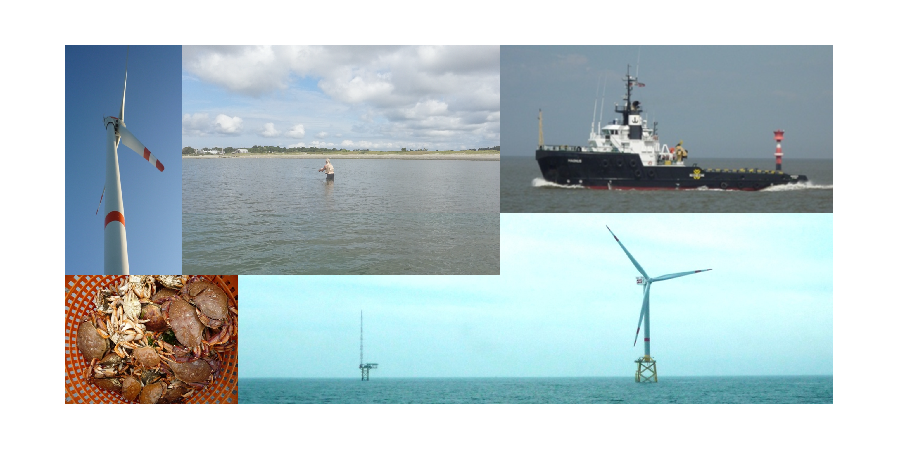
In New England, our team is still in the relatively early, exploratory stages of true marine spatial planning. Stakeholders are examining consequences of alternative spatial distributions of activities, and NatCap has been providing science-based tools and maps to support them. Our demonstration of new visibility and wind energy modeling tools assessed the suitability of the Deepwater Wind offshore wind farm, the likely first offshore wind energy farm in the U.S. New fisheries modeling that looks at distribution shift is based on IPCC climate change projections, downscaled to the region. The cumulative impact and ecosystem service mapping is for current conditions only. Rather than developing alternative future scenarios, NatCap has taken advantage of pre-existing scenarios and instead focused on new tool/method development.
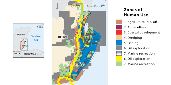
Belize
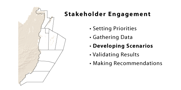
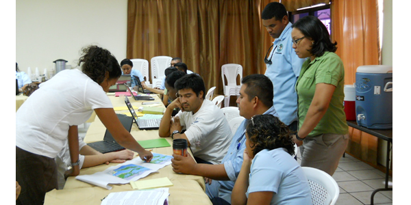
Scenarios reflecting three plausible futures for Belize's coastal development in the year 2025 were developed through a succession of government-led stakeholder meetings and workshops with communities along the entire coastline. These alternative scenarios are based on maps of the current distribution of ocean and coastal activities, existing and pending government plans, and stakeholders' values and preferences. The following set of rotating images describes this stakeholder-driven process where our government partner, the Coastal Zone Management Authority and Institute, mapped three zoning configurations describing the location and extent of future human uses. Overall, NatCap has been using its suite of scenario tools (including InSEAM and HRA) to support CZMAI where they are in their process.
Vancouver Island