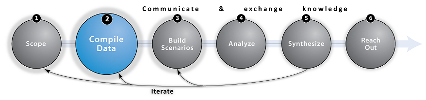
Step 2: Compile Data

Overview
Marine planning typically relies on both spatial and non-spatial information characterizing the coastal and marine space. An organized collection of information is useful for all types of participants involved in marine planning. Data allow you to visualize the locations of current environments and human activities and serve as a foundation for discussions of future plans. Often, data also serve as inputs to predictive models and marine planning decision-support tools. Other times data are used to visually depict or quantify elements of Scenarios. The uses for the data should be clearly identified before data are collected � often based on the goals established during the Scope and Analyze steps.
Generally, useful data include biophysical and oceanographic information such as elevation and bathymetry, maps of human activities such as transportation routes or fishing grounds, the distribution of coastal and marine habitats, and socioeconomic data like those provided by official censuses. When monetary valuation is a part of the assessment, additional data on market prices or property values may also be pertinent.

Tips
- Don�t spend too much time initially on this step. The Compile Data step can be a rabbit hole because you can collect and amass new data for forever. Only collect the data you need to reach your management and planning objectives.
- Use global or regional data sources to get a 'lay of the land' and identify data gaps/needs
- Show preliminary data to stakeholders; use expert feedback to refine information (see Iterate step)
- If funding allows, consider adding a dedicated GIS/data analyst to your team

Global Databases
There are many useful marine planning data sources available online, including:
Blue Habitats - Home to the global seafloor geomorphic features map
The International Monetary Fund - A range of time series data on IMF lending, exchange rates and other economic and financial indicators
MarineExplore.org - The world's ocean data at your fingertips; access measurements and create datasets
MODIS - Products from a variety of disciplines, including oceanography, biology, and atmospheric science
Natural Earth - A cartographic dataset available at 1:10m, 1:50m, and 1:110 million scales
NCEAS Data Repository - Research datasets collected and collated as part of research synthesis activities
BOEM/NOAA - MarineCadastre.gov - Data for the offshore energy and marine planning communities
Ocean Health Index - Annual global assessments: data, methods, and code for to represent ocean benefits to humans
OpenFisheries.org - A platform for aggregating global fishery data
OpenStreetMap - Download points, lines, and polygons representing a wide range of cultural features
Reefs at Risk Database - A global database of coral reefs and threats from a wide range of human activities
UNEP Ocean Data Viewer - Data for the conservation of marine and coastal biodiversity
USGS Global Visualization Viewer - A global, searchable database of historical Landsat imagery
USGS/WWF HydroSHEDS - A global, void-filled digital elevation model (DEM) at 90-meter resolution
The World Bank - Socioeconomic indicators and microdata by country
Worldpop - High resolution, contemporary data on human population distributions
Regional Databases
Click on the links or hover over the map markers to learn more about these regional marine planning databases.
Africa Marine Atlas - Africa
Alaska Shorezone Coastal Mapping and Imagery - USA
Australian Marine Spatial Information System (AMSIS) - Australia
Baltic Sea Bathymetry Database - Northern Europe
Biodiversity and Environmental Resource Data System of Belize (BERDS) - Belize
British Columbia Marine Conservation Analysis (BCMCA) - Canada
C3A - Regional database on the effects of climate change for the coasts of Latin America and the Caribbean
California DFW: Marine Region GIS Unit - USA
Coral Triangle (CT) Atlas - SE Asia
Gulf of Mexico Data Atlas - A catalog of regional datasets for modelers (time-series, climatologies, etc.)
Mid-Atlantic Ocean Data Portal (MARCO) - USA
NOAA National Centers for Environmental Information (NCEI)
- Merges data from the National Climatic Data Center, National Geophysical and Oceanographic Data Centers
Northeast Ocean Data Portal - USA
US Census Bureau - USA
UK Office for National Statistics - England and Wales
USGS National Elevation Dataset (NED) - USA
Do you know of other global or regional marine planning databases? E-mail us the details!

InVEST Helper Tools

Spatial and tabular data typically require some amount of processing before they can be plugged into Marine InVEST or other marine planning decision-support tools. Data processing is a challenging but necessary step. NatCap has created a Marine Planning Toolset and documentation to assist InVEST users with preparing and formatting data inputs for analyzing ecosystem service outcomes:
- InVEST 3.x Data Requirements - A spreadsheet listing the required and optional inputs for each InVEST model
- InVEST 3.x User's Guide - Each chapter includes a "Data Needs" section that outlines input and formatting requirements for InVEST models
- Marine Planning Helper Tools - A GIS toolbox for pre-processing data to be used with marine InVEST models (requires ArcGIS 10.x license)
- Experimental Software Tools - A discussion thread where NatCap staff and members of our community of practice share details about new software tools

Frequently Asked Questions (FAQ)
Q: Where can I find data for marine planning?
A: We have compiled a select list of global and regional marine planning databases (see above). Environmental NGOs and local government agencies often have data available upon request or through a data sharing agreement. Some partners and collaborators may also have a network of data sources. When requesting data, be clear and transparent about how your team intends to use the information. Another good source is the peer-reviewed scientific literature. Even if you don�t have data from your specific site to parameterize models, you may be able to find data from the larger region around your site in a published paper (e.g., supplemental text in Arkema et al. 2014). Generally, data about the spatial distribution and intensity of human activities that reflect your current and possible future management scenarios (i.e., zones of human uses if relevant to your process) will come from local government agencies. Maps of habitats and species can be acquired from global databases and local or international NGOs. Parameters and other input data for ecosystem service models generally come from scientific experts and their local data, the peer reviewed literature, and global databases.
Q: How do I handle data gaps?
A: Lack of data can present a serious challenge. A GIS analyst may be able to compile different sources of information and piece them together as a continuous data set (e.g., seagrass data sets for the United States in Arkema et al. 2013). Also, keep in mind that stakeholders often respond well to qualitative outputs too. Ultimately, it's important to be clear throughout the process as to where there is uncertainty or lack of confidence due to paucity of information.
Q: How much is enough data?
A: Revisit the project objectives and methodologies outlined during the scoping process. Begin by collecting enough data to do preliminary analysis or to run the selected decision support tool. It is often easier and more pragmatic to add and refine data throughout the process rather than waiting for "final" data.
Q: How does InVEST lack of data for model inputs?
A: InVEST was designed to be flexible and applied at multiple scales. We provide global and regional base data with InVEST to get you started running models in your study area right away. These initial runs can help you identify data gaps and guide future data collection efforts.

Links
- Cornu, Elodie, et al. "Current Practice and Future Prospects for Social Data in Coastal and Ocean Planning." Conservation Biology (2014). doi:10.1111/cobi.12310
- Kittinger, John N., et al. "A practical approach for putting people in ecosystem-based ocean planning." Frontiers in Ecology and the Environment 12.8 (2014): 448-456. http://dx.doi.org/10.1890/130267
- Koehn, J. Zachary, Daniel R. Reineman, and John N. Kittinger. "Progress and promise in spatial human dimensions research for ecosystem-based ocean planning." Marine Policy 42 (2013): 31-38. doi:10.1016/j.marpol.2013.01.015
- NOAA Digital Coast
- Port Resilience Planning Tool - Identify potential considerations (e.g., hazards, transportation) for planning around ports (includes data for 26 US ports)
- Coastal Country Snapshots - Summarizes community economic dependence on the coast and its vulnerability
- Benthic Terrain Modeler - Tools that scientists and resource managers can use with bathymetric data to classify and understand the benthic environment
- Essential Fish Habitat (EFH) Mapper - Interactive platform for viewing habitats necessary to fish for spawning, breeding, feeding or growth to maturity

Use-Cases
Use the expand [+] button to learn more about this data compilation step in the context of select NatCap use-cases.top
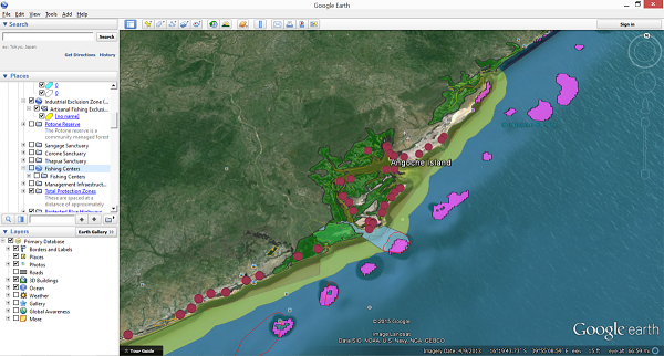
Mozambique
Mozambique is a data limited region. For this project, we worked closely with local partners to map spatial information about human uses, key habitats and animal species. Google Earth was used as a simple platform to create and share maps and enable non-GIS users to generate and edit spatial data. Conversations with local partners were critical in brainstorming simple ways to map key human uses, like artisanal fishing, which had not been mapped explicitly. In this example, by combining information about fishing centers, with estimates of how far fishermen travel from those centers, we were able to create a good representation of different fishing activities.
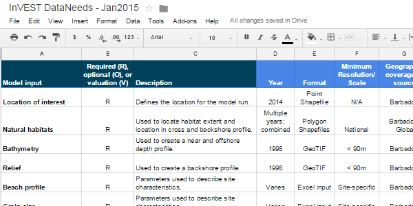
Barbados
Our core Barbados project team was dispearsed throughout four different offices in the United States. Since most of this collaboration was accomplished remotely, careful management of project data and outputs became essential. We used free accounts with Google Drive to store and track data we already had, datasets we could readily access if needed, and information we hoped to acquire. This online system helped our partners document project data sources, including spatial resolution, map units and scale. Preliminary results from InVEST models identified additional data needs and made it clear to our in-country collaborators how these data would be used in the assessment.
New England
The team in New England is using a variety of data sources to tackle some wide-ranging research questions. The Northeast Ocean Data Portal is a comprehensive online portal for marine planning-relevant data. The US Geological Survey and Rhode Island Geographic Information System offer detailed digital elevation models (DEMs). We are also using NOAA trawl survey fisheries and oceanographic data.